Wednesday, September 30, 2020

Tahquamenon Falls........darn hard to pronounce, darn worth seeing!


Upper Tahquamenon Falls!

We had seen enough pictures and had enough people recommend Tahquamenon Falls to know that it was going to be a "must see" for us.  The recommendations had been mostly written recommendations so we weren't quite sure of the proper pronunciation.  We had pronounced it many different ways, but none of them were correct.  Tahquamenon rhymes with phenomenon.  No matter how you pronounce it, it's well worth seeing!

Tahquamenon Falls

The drive to the falls was close to an hour and a half, but as with all the drives we've made in and around the Upper Peninsula, it was just as much fun and scenic getting there as it was once we arrived.  Tahquamenon Falls is actually two separate falls, the upper falls and the lower falls.  There is a four mile trail that connects the two falls, however, it is listed as a "difficult" hike.  Like most people, we opted to drive between the two. 

Another view of the Upper Falls

At more than 200 feet wide and with a drop of close to 50 feet, the upper falls is the larger of the two.  The lower falls is actually a series of five smaller falls that flow around a small island.  The water, which during the spring runoff can flow at up to 50,000 gallons per second was flowing at around 3,000 gallons per second on this early fall day.  The water which originates upstream in cedar swamps has a brown color to it, as it lands in the basin it produces a white foam.  With brown water and white foam, the falls have deservedly earned the nickname "The Root Beer Falls".


Along a short trail near the Upper Falls


The left side of the Lower Falls


The right side of the Lower Falls


Alger Falls.......a nice roadside waterfall near Munising

Our trip to Tahquamenon Falls was yesterday (Tuesday).  Today we were back on a trail in the Pictured Rocks National Lakeshore.  Today's hike was part of the Little Beaver Lake Trail.  Our version was a little under six miles in length.  It was a little muddy in a small section but otherwise a great hike along a trail that is well traveled on the weekends but that was practically deserted on a cloudy, cool and damp Wednesday.  The hike included a section along the breezy shore of Lake Superior as well another section along Little Beaver Lake.  There's a longer loop version of this trail that encircles the entire lake (Little Beaver Lake not Lake Superior) and is over eleven miles in length, but we're saving it for another day.

Day Hikes In Pictured Rocks National Lakeshore


A tunnel of trees on the drive to Little Beaver Lake


We shared the trail with this guy for a minute or two.


One of several very interesting rock formations along the trail.  It was probably a few million years in the making.


Checking for bear in a small cave........thankfully there weren't any lurking inside.


We looked both ways along the shore of Lake Superior and didn't see another person!


Great color across Little Beaver Lake!

Little Beaver Lake one more time!


Marquette...........Sugarloaf Mountain, Presque Isle Park and an unexpected roadside attraction

A roadside surprise!
 

Forty miles west of Munising is the city of Marquette.  Marquette is a "college town" with a population of around 24,000.  You might think that Marquette University is located here, but if you do you'd be wrong.  Marquette University is actually located in Milwaukee, Wisconsin.  The city of Marquette, Michigan is home of the Northern Michigan University Wildcats.  On our way to Sugarloaf Mountain we drove by the campus which has around 8,000 students.  Like the rest of what we saw in Marquette, the campus was very impressive, especially with the various colored leaves serving as a backdrop.

Marquette

The drive from Munising to Marquette was easy and very scenic the entire way.  Out Beth's window was a steady dose of Lake Superior and on my side a combination of marsh, rivers, lakes and of course plenty of colorful leaves.  I don't have much of a sample size, but kudo's to the Michigan Department of Transportation for the numerous roadside parks that we've seen as we made our way through the Lower Peninsula and around Munising.  They're numerous, offer great views and most have picnic tables, grills and benches.  Well done!

Taken from one of the numerous roadside parks between Munising and Marquette

 According to the Weather Channel the expected rain wasn't supposed to start until the middle of the afternoon, however I guess Mother Nature didn't get the message because there was already a light shower.  Thankfully it never got any harder and the canopy of leaves served somewhat as an umbrella. Our real umbrellas are safely tucked away in Florida. 

The Sugarloaf Mountain Trail is a relatively short (1.5 mile) loop trail.  The highlight of the trail is when you reach the top where there are three separate viewing platforms that offer panoramic views of the city of Marquette, the surrounding rolling hills and of course Lake Superior.  One thing we learned by experience about the trail is that although it is a loop trail it has two different levels of difficulty.  If you go up the left side from the trail head you'll tackle a more natural, less clearly marked and steeper hike.  Going up the right side from the trail head, you'll encounter a wider, smoother and better maintained trail.  Of course we didn't take time to look at the informational sign near the parking lot so we took on the steeper (although still nothing more than moderate) left side as we made our way up.  Ironically at the top of the trail, near the viewing platforms is a larger, more prominent sign with arrows pointing out "easy" and "difficult".  Not wanting to miss out on anything the trail had to offer we took the easy route down.  

Spectacular ground cover and leaves along the Sugarloaf Trail


Nearing the top of the Sugarloaf Trail!


The view from the top!

Another view from the top of Sugarloaf Mountain!


Now we know!

Presque Isle Park, not to be confused with Presque Isle State Park which we recently visited in Erie, Pennsylvania, is a 323 acre county park on a small peninsula that reaches out into Lake Superior.  The park features a very nice loop around the perimeter that can be hiked and biked at all times and driven at certain times.  No matter what form of transportation you use, you'll get great views of the lake and rocky steep cliffs along the shoreline.  Our clothes were a little damp, it was still drizzling, slightly windy and a little chilly so we opted for the cozy confines of the "silver bullet".  We did stop a couple of times to more fully take in the amazing views.


Lighthouse from Presque Isle Park


Presque Isle Park

On the way up to Marquette I noticed a small roadside attraction that caught my eye.  It was the Lakenenland Sculpture Park.  In my shallow brain I made a note, "that looks interesting, if I see it on the way back I'm going to pull in and see what it's all about".   As we made our way back towards Munising we passed it before I could safely slow down and turn in.  There wasn't any traffic coming so I quickly did a U-turn and pulled in, and we were both glad we didn't miss it!  The Lakenenland Sculpture Park is owned by Tom Lakenen, a sculpture artist who has turned tons of scrap metal into amazing pop art sculptures of various sizes and shapes.  The park, which you can walk, drive or in the winter snowmobile through is open 24/7, 365 days a year.  There is no admission fee, but donations are appreciated.  It is well worth the investment of spending a little time meandering through the park admiring and marveling at what he has created.  So much so that you'll gladly want to drop a few dollars in the donation box on the way out.  

A few of the more than 80 sculptures on display................

Lakenenland Sculpture Park

As I was finishing up the above paragraph of this blog an eagle with a large fish flew by our widow being chased by a number of much smaller seagulls..........nature is freaking awesome!


Monday, September 28, 2020

Munising, Michigan..........

Sunrise and coffee in our backyard and on the shores of Lake Superior!  The land mass across the way is part of Pictured Rocks National Lakeshore.  

Neatly tucked away on the shores of Lake Superior's South Bay is the small township of Munising, our home for about the next four weeks.  Munising is surrounded on the other three sides by the Hiawatha National Forest.   North of Munising, sitting in the bay is Grand Island, which lists it's population as 47.  You can catch a ferry from Munising to Grand Island for a day of hiking and biking fun.

Grand Island

Around 3,000 people are fortunate enough to call the picturesque township of Munising their permanent home.  Our "home" for our time in Munising is a beautiful and spacious Airbnb with the chilly waters of Lake Superior about twenty steps out the back door.

Nah.......it wasn't a big one, just the bottom of Lake Superior.  That's the tip of Grand Island in the upper right corner.

Munising is a four season destination for outdoor enthusiasts. It's popular for camping, hiking, biking and fishing during the warmer months.  When the temperature drops, cross country skiing, snowshoeing, ice fishing, ice climbing and snowmobiling become the activities of choice.  I read that the average high in January hovers around 25 degrees.  I'm sure the snow and ice are beautiful but I imagine we'll limit our visits to when it's a little warmer. 

The incredible ground cover will be snow covered in a couple of months.


Munising

A year round attraction to the area is Pictured Rocks National Lakeshore, a geological masterpiece of color along the steep cliffs between Munising and Grand Marais.  The park has 42 miles of shoreline and covers over 73,000 acres (114 sq. miles).   Over 500 million years of weathered erosion to the sandstone rock, and seepage from the minerals stored within the rocks, the steep, sometimes 200 foot high cliffs are as colorful as a large box of crayons.  We've enjoyed some views of the rocks along the coastline as we've hiked some of the trails in the National Lakeshore Park.  The consensus is that the best way to view the Pictured Rocks in all their glory is from a boat.  We'll be doing that next week when a couple of special friends from back in our Texas days are going to join us.  There will be more on Pictured Rocks in future blogs.

A tour boat going by Miners Castle in the Pictured Rocks National Lakeshore Park

Miners Castle

A seasonal attraction of the Munising area is happening right now.  Summer is giving way to fall and in this part of the country, the temperatures drop fast.  Along with the changing temperature comes the changing leaves.  We really enjoy the fall foliage and the Upper Peninsula is a great place to take in the change of seasons.  A recent article in USA Today listed the Upper Peninsula at the top of their list of the top ten places to enjoy the fall foliage in 2020.  Thankfully the Upper Peninsula is a little difficult to access so the crowds are much smaller here than they are in some of the other locations listed in the top ten.


A sampling of some of the fall foliage in our neighborhood.......


USA Today 10 Beautiful Places To See Fall Foliage

The leaves were already changing when we arrived three days ago.  In getting familiar with the area, we've already enjoyed several hikes including ones to Munising Falls, Miners Falls, Miners Castle, Miners Beach and Sand Point.  As we've been out and about we see more evidence every day that green is giving way to shades of red, orange and yellow and the peak is only a week or so away. Thankfully we'll still be around to take it in!     

Munising Falls

Miners Falls


Miners Beach

Miners Beach

Miners River

Kayaking is popular at Sand Point!

Sand Point Marsh Trail.......a nice, short elevated boardwalk trail.

Along the Sand Point Marsh Trail

Sand Point Beach

Happy Hikers at Sand Point Beach

Wrapping up the day around the backyard firepit.


Sunday, September 27, 2020

Michigan's Lower Peninsula...........Trolls for a day!


The Mackinac Bridge.......connecting the Trolls and Yooper's since 1957

We had a fun and short five night stay in Florida celebrating a very special 92nd birthday.  Then it was back to the Pittsburgh airport to retrieve the car (aka. The Silver Bullet).  Soon we were on our way to Michigan's Upper Peninsula, but our first nights destination was Midland, Michigan, about a six hours drive from Pittsburgh.  

The Birthday Queen!

The drive was uneventful and we arrived at the hotel around 9:00 PM.  A little tired, but no worse for wear.  We were up early the next morning and on the road shortly after 7:00.  When we left Midland the fog was really thick, but from what we saw it was a nice looking town that would be fun to explore some time.


After the fog cleared the drive from Midland became quite colorful

The state of Michigan is quite large and is divided into two halves, the lower peninsula and the upper peninsula.  The dividing line between the two is the Straits of Mackinac, and the Mackinac Bridge that connects the two.  Residents of the Michigan Peninsula are divided into two groups.  Trolls, which are lower peninsula residents, cleverly named because they live below the bridge.  If you live in the Upper Peninsula, you're affectionately known as a Yooper.  For most of the next month we're going to be Yooper's, but first was a bit of exploring where the Trolls live.

We had a few destinations that had been recommended to us many times over the years.  While we weren't able to spend too much time in any single place we wanted to see and do as much as possible as we made our way toward Munising, our home in the Upper Peninsula.

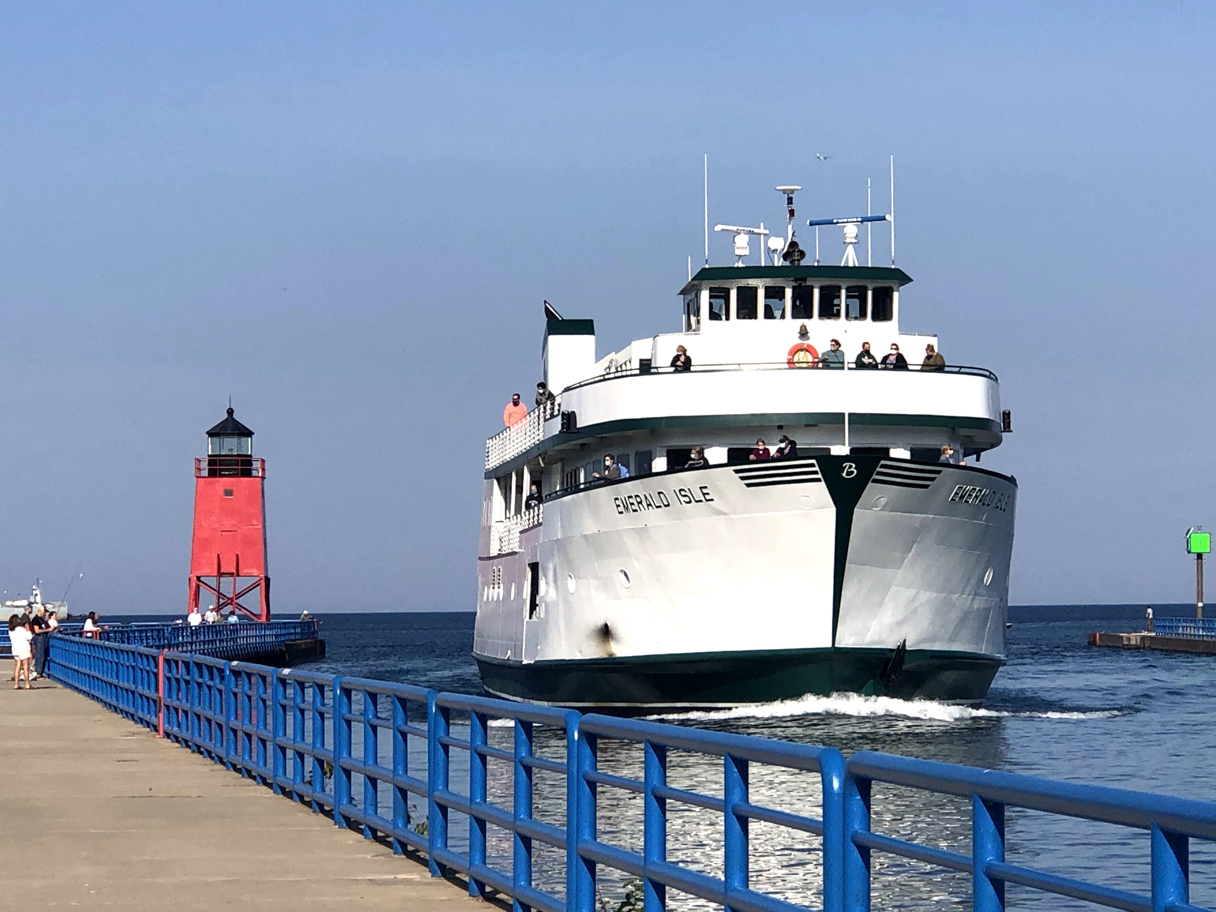
It was just over a two hour drive to our first destination, Charlevoix, a small city of around 3,000  pinched in between Round Lake and Lake Michigan. The city was named after a French explorer who traveled the great lakes and was rumored to have hunkered down in the area during a heavy storm.  We enjoyed walking around the small, picturesque downtown and along the Round Lake Channel to the South Pier Light House.

Mural of the Charlevoix Bridge in downtown.

Round Lake

The Round Lake Channel looking out towards Lake Michigan.  The Charlevoix Bridge is right behind us.

Ferry entering the Round Lake Channel.  There is seasonal service to Beaver Island.

Downtown park, bandstand and marina overlooking Round Lake

Charlevoix

From Charlevoix it was just a short 25 minute drive to Petoskey, (population 6,000).  It is also located on Lake Michigan.  Predictably it's downtown was larger and more vibrant.  There was a downtown Farmers Market that was doing a pretty brisk business.  Bayfront Park was a nice place to enjoy a very good takeout pizza (Mighty Fine Pizza)while taking in views of Lake Michigan.   We were also entertained by boaters launching their boats for a day on the lake.


There was plenty of color in downtown Petoskey!

..........and more color!

The downtown Farmers Market is every Friday from June through September.  This was the last one for the season.

Petoskey

From Bayfront Park in Petoskey we could look across Little Traverse Bay to our next destination, Harbor Springs (thanks Ashley and Jason for the recommendation).  Although it was early afternoon, the day was passing by pretty quickly so we only did a brief drive along the waterfront and through the downtown.  Harbor Springs is smaller than both Charlevoix and Petoskey.  It certainly looked like a place where we would enjoy spending more time.

Harbor Springs

On our way out of town we passed through a section of the Tunnel of Trees. a very scenic highway that as the name implies gives the impression of being in a tunnel formed by trees.  The leaves were beginning to turn from green to various shades of yellow, orange and red making for a spectacular drive.

Goodhart General Store located along the Tunnel of Trees

Fall is in full swing at the Black Barn Farm

Pigs doing what pigs do best at the Black Barn Farm!

We also made a brief stop in Mackinaw City.  While not quite as "touristy" as places like Niagara Falls and Pigeon Forge, TN it did have plenty of T-shirt shops and fudge stores.  Tourists in Michigan are often referred to as "fudgies" because they tend to gravitate to locations that have a lot of fudge stores.  Mackinaw City also had great views of the Mackinac Bridge, the gateway to the land of the Yooper's.

Fudge was plentiful in Mackinaw City...........for some strange reason we didn't partake!

Being a Troll for the day was fun.  There's plenty more to see and do in the Lower Peninsula, but for this adventure we're going to be focusing on the Upper Peninsula and being Yooper's.