Sunday, January 28, 2024

Breezing around Stanley, Falkland Islands.

There was only a little rain……
….but a whole lot of wind!

After four days, we left Antarctica behind and headed north back across the Drake Passage to our next port of call, Stanley, Falkland Islands.  

We had the “Drake Lake” heading south to Antarctica.  The northbound passage was a little different story.   We had two days of a pretty good “Drake Shake”.  Winds were blowing around 50 mph and waves were in the eighteen foot range.  In spite of the bumpiness, we tolerated it without any problems.  In hindsight, it was kind of nice to experience both the “lake” and the “shake”.  

The Falklands (there anre two main islands, creatively named East and West) are located approximately 300 miles from the Argentina coastline.  Around 4,000 people call the Falklands home, many who have been there for multiple generations.   If you’re keeping score, there are around 100 times as many penguins in the Falklands as there are humans!  

The great majority of the Falkland Islands residents live in Stanley

The Falklands are self governed, but overseen by the United Kingdom.  There has been disputes over ownership of the islands for several hundred years.  In 1982, Argentina invaded the Falklands in an attempt to take control.   They underestimated the resolve of the British, and Margaret Thatcher,  and were soundly defeated.  The islands have been peaceful since that time, and the defeat of Argentina remains a source of great pride to the several thousand residents of the islands.  

Stanley Anglican Church, the southern most Anglican Church on the planet!

We had visited the Falklands about ten years ago on a previous cruise.  We enjoyed spending that day at a King Penguin colony, but we  didn’t get to see any of the small, well maintained town of Stanley.  

This time around we decided to stay in the town area.  We hiked from town to Gypsy Cove where there was a small colony of Magellanic Penguins.  The hike was quite scenic and somewhat enjoyable.  It would have been more enjoyable if the wind wasn’t blowing near Category 1 hurricane strength the entire thirteen miles!  We were pretty “wind blown” and wiped out by the time we returned to the pier area.   Thankfully we had a few more hours to look around and really enjoyed their national museum (The Historic Dockyard Museum) which was located along the waterfront.  If you end up in Stanley be sure to put the museum on your agenda. 

penguins in Gypsy Cove

We were watching the penguins on the beach.  When we turned around we found that this guy had been watching us!

The Lady Elizabeth has been rusting near Stanley since 1913.  

One of the many displays in the museum.    

If the wind is whipping and you want to hike to Gypsy Cove, good luck!


Antartica…..a little difficult to reach….impossible to describe!

The seventh one is checked off!

We did it!   We’ve now visited all seven continents.  There have been so many amazing experiences along the way.  Some of them are easy to describe, others difficult to describe, and a few that are downright impossible to put into words.  Antartica falls into the impossible to describe category.  

Size wise Antartica is huge.  It’s larger than the contiguous United States.  According to what we’ve learned from the Antartica experts on board, 61% of the world’s fresh water can be found in Antartica….as ice.   Ironically Antartica is considered a desert.  The accumulation of ice and snow has been millions of years in the making.  

Antarctica is the only continent without a human population    Thanks to some forward thinking people the Antarctica Treaty Alliance was signed on December 1, 1959.  The treaty was signed by twelve countries (including the US), to protect and preserve the fragile and important ecosystem.  The treaty provides oversight for all activities in Antarctica.   Scientific research projects must be approved and tourism is very limited.   From the limited research I did on the treaty it appears to be working extremely well, and is a model of international cooperation for the benefit of everyone.   Hopefully it continues!

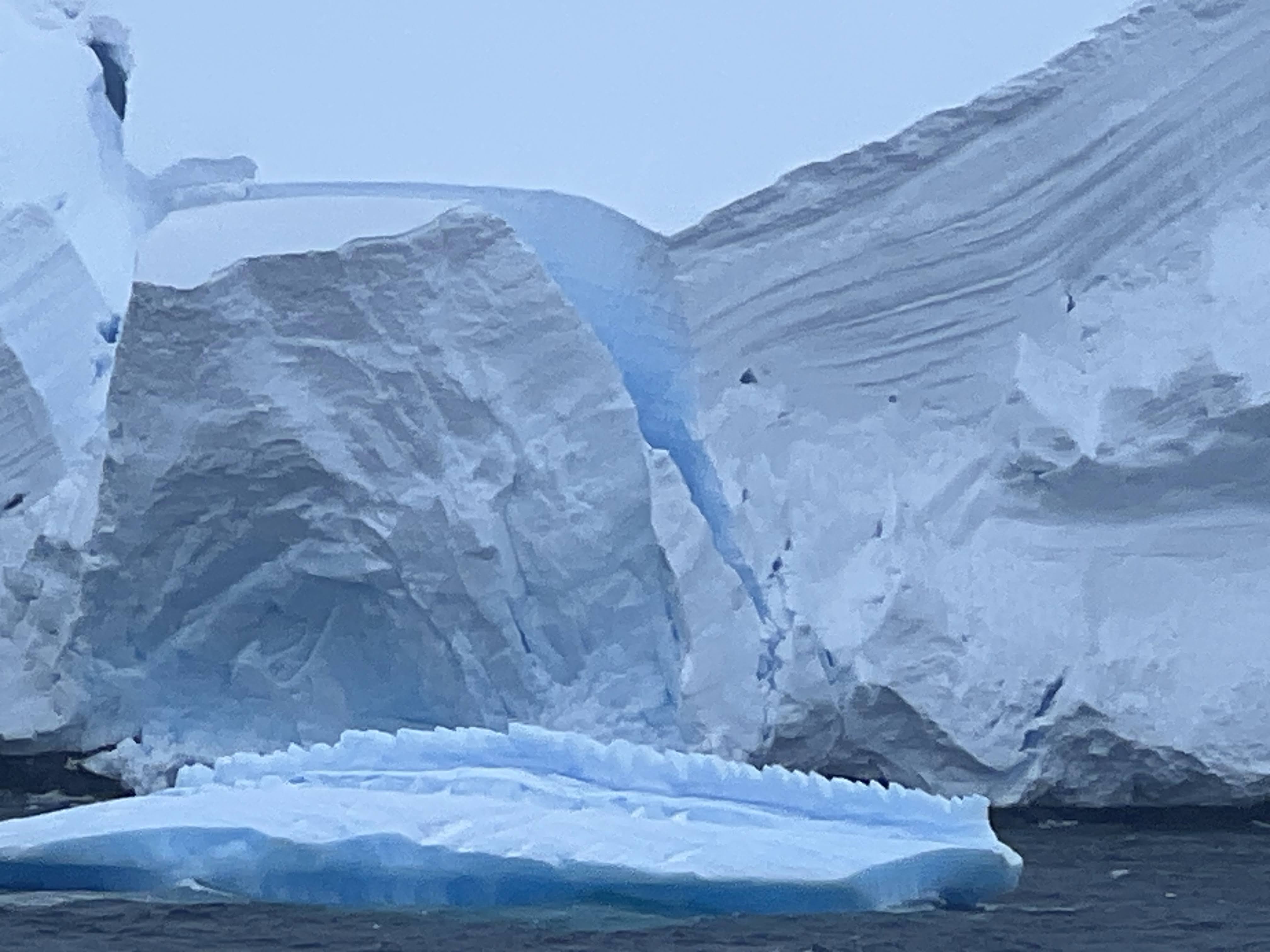
From Cape Horn we cruised southward across the Drake Passage for two days.  We felt very fortunate that we had the “Drake Lake” both days…….smooth water and dropping temperatures as we made our way.   We’ve seen icebergs on other adventures, but we quickly realized that there are icebergs and then there are Antartica icebergs.  It wasn’t unusual to pass between two icebergs that appeared to be much larger than the ship.  We did learn that no matter the size of the iceberg, only around 10% is visible.  We didn’t see it, but we were told that the largest iceberg out there is A23A and that it is currently 4 times the size of New York City.  Thankfully we have on board skilled ice pilots who along with our very personable captain kept us from turning into the Titanic.

The Cape Horn Lighthouse. A family of four and a cat live there.  Their nearest neighbors are a few hundred miles away!

One of many Albatrosses that entertained us around Cape Horn.  

One of the first iceberg sightings as we traveled south across the Drake Passage.  Note the lake conditions.  There are no pictures of the “Drake Shake” conditions because the outside decks were closed.

Our cruise took us to the Antarctic Peninsula, which with a little imagination looks somewhat like Florida jutting out.  We had four wonderful days cruising in and out of bays and channels, as well as getting close up looks of both Deception and Elephant Islands. All the while we were marveling at the scenery and enjoying watching hundreds of thousands of penguins swimming along beside the ship and standing guard over their babies on the rocky shore line.   We also had a daily dose of whales, sea lions, Antarctic birds and snow.   

The weather was about as cooperative as the weather can be in that part of the world.  The skies were mostly overcast with the temperatures ranging from the single digits to the upper twenties.  It was never intolerable when we were outside, especially since we were never more than a few steps away from being out of the wind and weather and back in the cozy confines of the Oosterdam.  Sunset was close to midnight and sunrise around 4 am, but it never really got completely dark.

It really is impossible to describe Antartica with words.  Pictures capture just a glimpse of how spectacular this frozen continent really is.  Below are some of our favorites.  I’ve captioned some with specific points of interest……enjoy!

Approaching the Antartica Peninsula! 


The Palmer Research Station.  It’s one of the US Research Stations.  In the summer it is staffed by around 60 people.  During the winter it is staffed by around 30 people.  


The dark line leading to the water is the penguin trail.  There are a few penguins near the water’s edge.  

The great majority of the coastline around Antarctica is classified as “glacier”. 


A future iceberg calving off the glacier.

The two things that look like logs are actually humpback whales.

Iceberg with a built-in swimming pool.  We had seen one earlier that had a seal frolicking around inside.  


Morning Tai Chi by the indoor pool

Penguins on the slope!

Penguins on the Rocks!

Penguins chilling on ice!

Polar plunge in the outdoor pool.  No!  We did not participate!


We didn't earn the Polar Plunge Certificate.  However, we were inducted into The Order of the Moss Back for rounding Cape Horn and The Order of the Red Nose for traveling to Antartica.  I'm not sure what benefits come with being inducted other than these spiffy certificates.  


Elephant Island.  It was so named because the island resembles the head of an elephant.  It was here that 22 men spent four months after their ship was destroyed by an ice pack. They survived under lifeboats, eating penguins and seals.   True to his word, the expedition leader  (Ernest Shackleton). who left to seek help did come back to rescue them.  The small thing sticking up in the lower middle of the picture is a monument to the rescue.  

Penguin covered rocks at Elephant Island.  


Sunday, January 14, 2024

Ushuaia…….”the end of the world”!


The End of the World!

While it’s been pretty well proven that the world is round, if you travel far enough south in South America you’ll likely end up in Ushuaia, Argentina.  Although it’s quite remote, it’s a surprisingly vibrant city (population is around 90.000) that is the world’s southernmost city and proudly proclaims itself as “the end of the world”.  

Cruising towards Ushuaia!  A huge glacier feeding a huge waterfall. 

Like Punta Arenas, Chile, Ushuaia is a gateway city to Antartica. For our journey, it is our gateway city.  When we leave here our next destination will be four days of scenic Antartica cruising.  

Arriving at Ushuaia!

Although it’s mid-summer, it’s a bit nippy here at the end of the world.   Today’s high was around 40.  Sometimes it was sunny, sometimes cloudy.  There was a little drizzle, a little sleet and even a few snowflakes.  Weather wise, the only thing consistent was the steady wind that made it seem colder than the actual temperature.

We arrived around 11:00, and have a late departure, which has given us a full day to enjoy the city and surrounding area.  We hired a cab for a three hour tour that took us to the Tierra del Fuego National Park, which is just a short 30-40 minute drive from the city center.   The park is close to 300 square miles in size, so our visit just hit some of the many incredible highlights.   All the pictures between this paragraph and the next one were taken in the park.


Our cab driver!

After returning to the city we said goodbye to our friendly cab driver.   His English was as bad as our Spanish, but we had a lot of fun along the way.   We still had plenty of time to walk around the city before returning to the ship.   It’s getting close to time to depart the end of the world……we’ll be heading further southward to what I guess is the bottom of the world.   The adventure continues!


Main Street Ushuaia 

Near the city center

Adios from Ushuaia!

Saturday, January 13, 2024

Punta Arenas


We had a whale of a good time in Punta Arenas!

It took two days to cruise from Puerto Chacabuco to Punta Arenas.   Most of the journey was through the calm and very scenic Chilean fjords.  Along the way we passed the Amalia Glacier, which is located in the Bernardo O’Higgins National Park (Chile has 42 National Parks).  This large, tidewater glacier covers over 60 square miles, making it one of the country’s largest. 

Great scenery in the Chilean fjords!

The Amalia Glacier!

Punta Arenas, which has a population of just over 125,000, serves as the capital city of Chile’s southernmost region.  Because of its location, Punta Arenas has a long history of being a vital port city for ships passing around Cape Horn.  Its importance was significantly diminished by the opening of the Panama Canal in 1914.   At that time, a visionary business woman named Sara Braun was credited with encouraging the diversification of the economy to include agriculture (sheep and cattle).  Today Punta Arenas, like most of the country of Chile, has a diverse and thriving economy.  Tourism in the region continues to grow as Punta Arenas serves as a starting point for Antartica adventures.


We enjoyed roaming around the city, even taking time out for us both to get our hair cut.  During our time roaming around we experienced all types of weather, ranging from sunny blue skis to thick clouds, a bit of rain, a little sleet and a steady wind that made the mid-forty degree temperature feel a little chilly…..no pun intended.   

Haircut Day……Beth’s is a little more complicated than mine!

Sara Braun Palace

The cemetery is known for its large, family crypts and is a popular tourist attraction that’s worth visiting.  Sara Braun’s final resting place is in the cemetery which is named after her. This is not her crypt.   

Plaza de Armas.   Many Chilean towns have a city square named the same thing!     It looked like everyone was rubbing the foot of the statue located there.  We assumed it was for good luck so we rubbed it as well.  

We found the Oosterdam!


Tomorrow we head a bit further south, and will leave Chile behind.  We will be docking in Ushuaia, Argentina for a few hours before heading further south to Antartica!   
To reach Antartica we’ll be crossing the Drake Passage, which at times is known as the Drake Lake because the water is as calm as a lake.  Other times it’s known to produce the “Drake Shake”!  Right now it looks pretty good, but we’ve been warned it can change quickly and often.  We will keep you posted!!