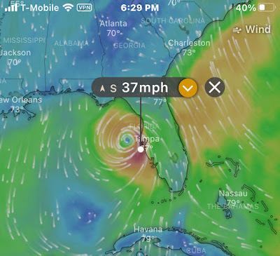
Eta formed in the Caribbean Sea. It moved westward and hit Nicaragua as a Category 4 Hurricane. It moved back into the Caribbean Sea south of Cuba and regained strength before heading into the Gulf of Mexico. We're the blue dot on the map!
According to the "Windy" App.....it's windy out there!
Throughout the day the storm has continued to move upward along the Florida Gulf coast. Thankfully, it has lost some strength and has been downgraded to a tropical storm. We've had a lot of light rain and a few heavy downpours throughout the day. Although the winds have not been much higher than 40 miles per hour on shore, wind gusts just offshore have been reported as high as 70. The rain, winds and high tide, which is around 9:00 PM, may make for a few bumpy hours this evening.
By tomorrow morning Eta will have crossed the state and be heading out into the Atlantic Ocean where it will break up. Hopefully it won't leave too much damage behind. We should wake up to sunny skies while we wait to see what else 2020 can throw at us!

