Sunday, October 11, 2020

Kitch-iti-kipi, Fayette and more color!


Kevin, Stuart and Bob enjoying a nice fall morning in the Upper Peninsula!

Sadly in these days of social distancing and wearing masks it's a little more difficult to visit with others while traveling.  Through the years many of the places we've visited and things we've seen have been from recommendations we've gotten from people we met along the way.  Hopefully, we've been able to share with them some ideas that they have enjoyed along their journey also.

Kitch-iti-kipi had been somewhat on our radar screen but not a high priority.  Fayette was not a place that we had even heard of a few days ago.  Thankfully we visited for a few minutes with a couple at an incredible overlook just a mile or so from where we are staying.  When Beth mentioned Kitch-iti-kipi they recommended it and suggested Fayette as well.  We did a little research and saw that those two destinations are somewhat close to each other and that it would make for a nice daytrip.  Our plans for Saturday were set!


As I had mentioned in a previous blog, there are so many scenic overlooks and parks in the Upper Peninsula.  This one is about a mile from where we are staying.  It's where we got the recommendations for Kitch-iti-kipi and Fayette.

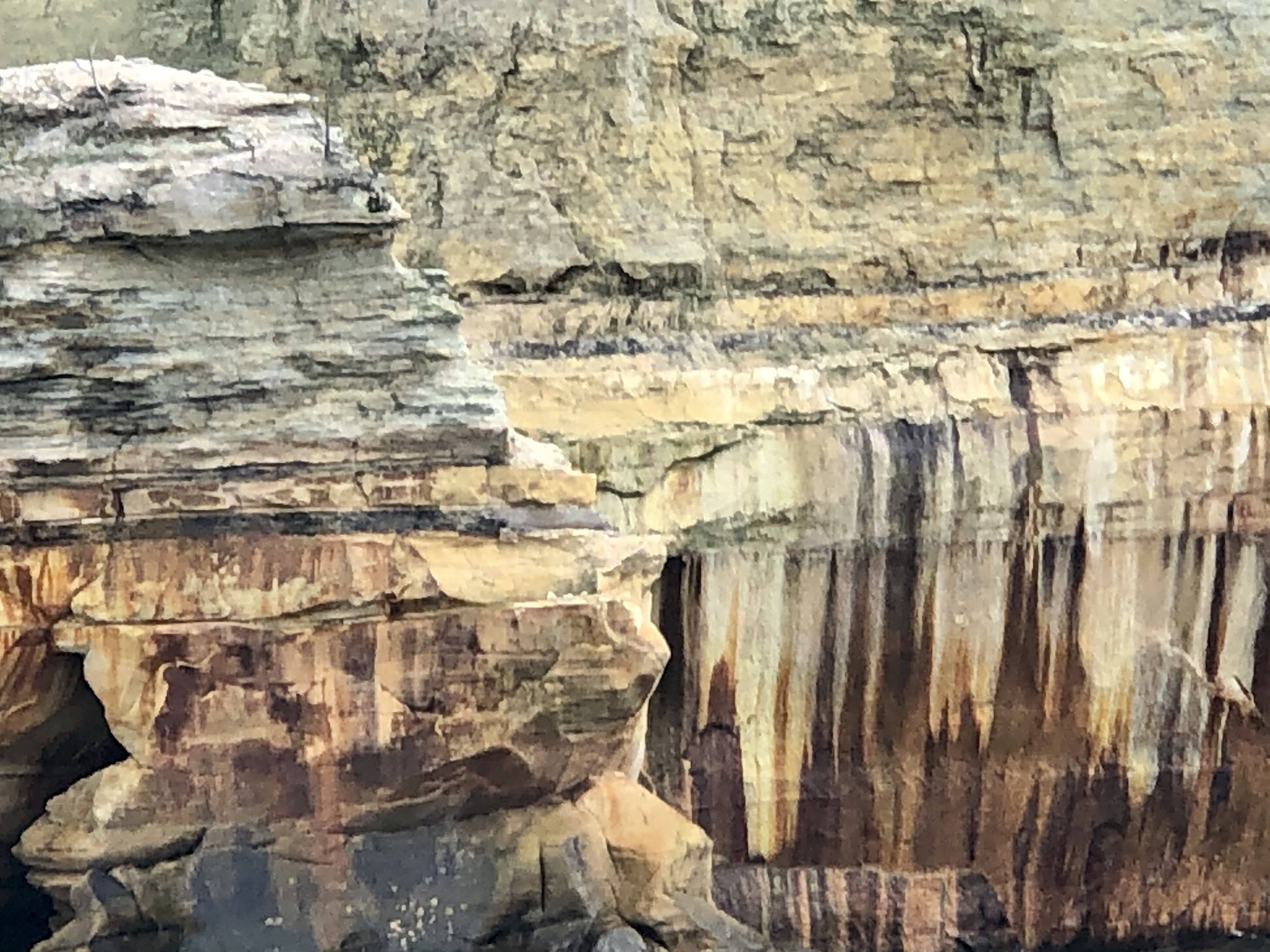
Kitch-iti-kipi, as it was referred to by the Native American Ojibwe tribe, means "big cold spring", and that's exactly what it is.  With a flow of over 10,000 gallons a minute it is actually Michigan's largest natural freshwater spring and at a temperature of 45 degrees the water is plenty cold.  It's accurately named and an enjoyable place to spend a little time.


The Big, Cold Spring!

Kitch-iti-kipi is located in the Palms Book State Park close to the town of Manistique.  It was about an hour drive for us to reach the park.  There was a visitors center/concession area that was closed for the season.  The park was still doing a somewhat brisk business even on a chilly, breezy fall morning.  We  asked the employee at the entry gate what else there was to do in the park other than visiting the springs.  He thoughtfully and honestly answered "not much".  Not only was the springs accurately named, but the gate attendant was accurate in his answer.  

Palms Book State Park

In spite of only the single attraction, it was quite interesting and scenic.  There is a boardwalk around part of the spring that makes for easy viewing, but the best views are from over the spring.  There is a glass bottom, wooden raft that floats directly over the 50 foot deep spring that is "self propelled".  The raft holds around fifty people (it looked like we had about 25 on ours).  It's attached to a cable and a big wheel that "volunteers" on the raft turn to gently guide the raft out and back.  The leisurely float over the crystal clear water that was teeming with huge trout took about 15-20 minutes. It made for a very enjoyable time, especially since there were plenty of others volunteering to power the raft!


That's the raft being loaded with another group of passengers.


I should have brought my rod and reel!

I made a rookie mistake yesterday that I'd like to share in case you visit the Upper Peninsula.  Some areas are quite remote with limited cell service.  When we left the house I set the google maps on my phone to Kitch-iti-kipi.  As usual, the directions were perfect and we had no hesitation when we found ourselves on an unpaved road for about five miles.  My mistake was not setting all our destinations in the phone before heading out.  There was no service in or near the state park.  We were never lost, I knew right where we were the whole time, but I did make a wrong turn that sent us in the opposite direction of our next destination.  Oh well, we got to spend a little time in the town of Manistique and even have a few pictures to prove it.


If I hadn't made the wrong turn we wouldn't have had this picnic on the shores of Lake Michigan.....


......seen this statue of the legendary Paul Bunyan.........

or got this picture of the Manistique East Breakwater Lighthouose.....everything happens for a reason!

Fayette was a really pleasant surprise that we both really enjoyed.  Between the years of 1867 and 1891 it was a vibrant industrial town on the shores of Lake Michigan.   The town sprang up when the Jackson Iron Company built a factory to produce iron.  The "company town" that sprang up was completely self sufficient, with a large company store, hotel, school, church, music hall, doctor, barber and much more for the over 500 residents that called Fayette home.  As quickly as to the town sprang up, it met it's demise when the factory closed down due to decreasing demand.

As you could imagine, most of the buildings have been destroyed due to time and weather.  Thankfully some withstood the test of time.  They have been refurbished and replicas of some of the other commercial and residential buildings have been built.  Fayette is now an historic state park that is a great place to get an insight and understanding of one of the many "company towns" that existed at one time throughout the US.  We enjoyed a couple of hours looking around, but the winds coming off Lake Michigan were a little chilly.  The little bit of chill we got made me think about the challenges the residents of Fayette must have had once "real winter" hit their little town.


The remains of the main factory.


The hotel where good rooms could be had upstairs for $2.00 a night...or a "shared room" for fifteen cents a night!


The main section of town with the hotel in the background.


The Town Hall.  There was a barber on the first floor and a music hall on the second floor where the town band often played.


The Superintendent's House.  There were also "middle class" and "lower class" neighborhoods.


The Superintendent's home from across the harbor.


Another view of the main part of the town.

Fayette Historic State Park

We finished up the day with a great drive back to Munising along National Forest Road 13.  As with all the roads we traveled yesterday, the leaves were spectacular and we even found our next adventure! 

Below are a few views from the drive back to Munising. 


Friday, October 9, 2020

Mackinac Island........and a three Great Lake day!


In the foreground is the Catholic Cemetery on Mackinac Island.  In the background is the Protestant Cemetery.  Our tour guide pointed out that the Protestant Cemetery appeared to be much holier!  He also pointed out that there was a "No Alcoholic Beverages" sign on the Catholic Cemetery which he found to be a little strange.

We both got a little sad yesterday when we realized that we only have two more weeks in the Upper Peninsula.  It's an amazing place, with so much to see and do.  We're already looking forward to a return visit.  Munising is an excellent place to use as a base for exploring much of what the Upper Peninsula has to offer.  With Pictured Rocks National Lakeshore and Marquette close by, there's plenty of outdoor activities within a 30-45 minute drive to keep you busy.  Additionally, going east, west or south for a couple of hours you can do longer outings to include places like Tahquamenon Falls, the Porcupine Mountains and Mackinac Island.  These are easily doable in a day, however they will definitely be full day adventures.

East to Tahquamenon Falls had been checked off the list.  West to the Porcupine Mountains had been checked off the list.  Yesterday was our day to drive south to the lower portion of the Upper Peninsula to visit Mackinac Island.  The drive was an easy two hours on roads that at this time of the year are not crowded and very colorful.  

We caught the ferry from the small town of St. Ignace, which sits on the north side of the Mackinaw Bridge, and is known as the gateway to the Upper Peninsula.  St Ignace's slogan is "it's better above the bridge" and with all due respect to Mackinaw City (which is on the lower end of the bridge), we would agree.  St. Ignace was much less "touristy" than Mackinaw City.  I'm sure there may have been some, but we didn't see an overabundance of t-shirts and fudge shops like it's southern neighbor Mackinaw City.  


There's a big smile behind that mask!


Ferry arriving from Mackinaw City.........probably loaded with fudge and t-shirts

Ferry boats are also available from Mackinaw City.  The cost is approximately the same (currently around $27 round trip) and the time to reach the island is about the same (less than 30 minutes).  There is free parking with a shuttle service to the dock or paid parking at the docks.  Depending on the time of year you visit the island you may want to purchase tickets in advance.  The season on the island is ending within the next week so the number of visitors right now is very small (just the way we like it) so we simply purchased our tickets at the dock.

Shepler's Ferry

One thing that you may have noticed was that there are two different spellings for the word Mackinac.  It's a bit confusing, but here's what I have learned from a little research on the subject.  The Native Americans in the region actually called it Michilimackinac, the place of the "Great Turtle".  They believed that the island was a massive turtle that had risen up out of the waters to create the island.  For a period of time the entire region went by the name Michilimackinac.  Somewhere around 1820 it was shortened to Mackinac.  The founders of Mackinaw City opted for the phonetic spelling, while the island stayed with Mackinac.  The bridge that connects the Lower and Upper Peninsula, and also serves as the dividing line between Lake Michigan and Lake Huron, is spelled Mackinac. 


The Grand Hotel from the ferry.  The hotel currently has just under 400 rooms all of which are decorated differently.  It also boasts the "longest porch in the world" (over 600 feet).  The original construction of the hotel was 93 days........they needed to finish because they had booked all the rooms!


This is the Michigan Governors Summer Home.  It's been a tradition that the governor live there every summer for decades.


The Mackinac Island Marina and Waterfront

Mackinac Island is east of the Mackinaw Bridge and is therefore located in Lake Huron.  The island is around four square miles in size, making it somewhat small for an island but quite large for a turtles back.  The year round population is less than 1,000 residents, however, during the summer that number jumps considerably as the island resort comes to life.


Mackinac Island


Much of the island is a part of the Michigan State Park System.  It was actually the United States second national park from 1875-1895.  Yellowstone was the first national park if you're keeping score.

There is so much history and uniqueness about the island that it would be impossible to do more than scratch the surface in a blog.  Archeologists have excavated fishing camps on the island that date back to 700 AD.  Fast forwarding a bit, the British captured the island and Fort Mackinac in the War of 1812 by simply firing a warning shot and letting the US Commander know that his troops were greatly outnumbered and would be slaughtered.  The British then returned the island to the US though the Treaty of Ghent that was signed in 1815.


Marquette Park with a small section of Fort Mackinac in the background.

After the Civil War, Mackinac Island began to develop as a tourist destination. It has continued to grow and evolve ever since.  Currently Mackinac Island hosts about 1 million visitors per year, almost all of them visiting between mid-spring and early-fall.  As I had mentioned previously, Mackinac Island's 2020 season is coming to an end.  Some of the restaurants and shops along the Disney like Main Street had already closed.  They will soon be joined by the others and the hotels, leaving it a virtual ghost town after next weekend (October 18).


Main Street wasn't very crowded on a mid-week day, late in the season.  Doud's Market is the only "grocery store" on the island.  It's open year round for the permanent resident and few winter visitors.

A very nice feature of Mackinac Island is that practically all motorized vehicles have been banned from the island since 1898.  With very few exceptions, the only motorized vehicles allowed are emergency vehicles, service vehicles and snowmobiles in the winter.  One recent exception that naturally caused quite a controversy was back in 2019 when Vice President Pence visited the island and brought along his Vice Presidential motorcade with him.  Even without motorized vehicles, getting around the island is quite easy.  There are numerous bike rental places (or you can bring your own on the ferry), horse drawn carriages which serve as taxis, or walking.


Bikes are plentiful everywhere on the island.


As are horse drawn carriages.  There are two nine hole golf courses on the island that are separated by a few miles.  Golfers playing both courses actually ride in carriages from one course to the other.  


As suggested by our wonderful Airbnb host, when we got off the ferry we booked a narrated carriage tour.  The tour is a great way to learn some of the history, see a great deal of the island and get your bearings for further exploration by bike or walking.  Our guide was quite knowledgeable of the islands history and told numerous stories, often in a humorous manner.  


That masked woman two rows behind the driver is Beth


Arched rock with the blue waters of Lake Huron in the background.


The post office is believed to be the only one in the US to have never delivered a piece of mail.  All residents and business come to the post office to pick up their mail.

After the tour we set out to walk the 8.2 mile perimeter of the island.  In spite of there being very few vehicles on the island the perimeter is a narrow road that is designated as a state highway (M-185).  We covered the entire walk seeing numerous other walkers and bikers and a few horse drawn carriages, but no vehicles!  


Along the trail around the island.


Cannonball's snack shop is about half way around the island from Main Street.  It's a perfect place for a sandwich or snack if you're walking or biking around the island.


There are approximately 80 kids (K-12) that attend the island school.  Our guide pointed out that graduating classes are usually around 4-8 kids and that Senior Prom can be somewhat strange.


There's plenty of fudge available on Mackinac Island!

We were back in our Munising home by sunset.  Mackinac Island and views of three of the five Great Lakes in one day.........not bad!


Wednesday, October 7, 2020

Pictured Rocks National Lakeshore.........mostly in pictures!


Our Airbnb from the boat!

In 1966 the US Congress designated forty two miles of shoreline between Munising and Grand Marais as Pictured Rocks National Lakeshore.  The National Lakeshore designation was created to allow oversight by the US National Park Service to preserve these environmental, cultural and recreational lakeshore areas.  Pictured Rocks was the first area of four areas that have earned this designation.  Two are on Lake Michigan and two are on Lake Superior.

Annually around 750,000 people visit the 42 miles of shoreline and 73,236 acres that make up Pictured Rocks National Lakeshore.  As the name implies, the featured attraction are the 15 miles of steep, colorful cliffs that get their color from the minerals (iron, copper, manganese and limonite) contained in the spring water that seeps through the sandstone.  Additionally there are over 100 miles of trails, numerous campgrounds, sandy beaches, towering sand dunes and waterfalls throughout the park making it extremely diverse.

Pictured Rocks National Lakeshore 

We've hiked miles of trails enjoying many of the waterfalls along the way.  We've also visited several of the sandy beaches and dunes.  We enjoyed viewing some of the Pictured Rocks from the shoreline, but yesterday we got a closer look from a two hour boat cruise.  From May to October, Pictured Rock Cruises offers several different options of cruises (Classic, Spray Falls and Sunset) that take guests out on the lake to get the best view, not only of the pictured rocks but also of the East Channel Lighthouse on Grand Island.

Pictured Rocks Cruises

We took the two hour Spray Falls cruise which is similar to the classic cruise with an additional visit to Spray Falls.  The weather conditions yesterday were very favorable. It was a little warmer than it had been and the lake was "calm".  In spite of this, sitting on the upper deck of the boat it did get a little chilly and once we were out of the bay it was a little bumpy but well worth it.


Beth took this picture of someone she thought was me!  Masks were required on the boat and they were selling at 50% capacity to allow social distancing.


Here's Pictured Rocks the way it should be.........in pictures! 


The East Channel Lighthouse on Grand Island.  It was established in 1868 and deactivated in 1908.  The last lighthouse keeper and his wife had 12 children.  I guess he was keeping the flame burning in more ways than one!